Introduction
Gunung Rajah via Kuala Kubu Baru.
11.8km ascending. 11.6km descending.
Started at 6.36am. Reached the peak 7 hrs 30 min later at 2.05pm.
Started descending at 3.00pm, reached car park 5 hrs later at 8.00pm. Total hike time 12.5 hours (excluding rest time). Total distance 23.4km.
Huge gap on ascending-descending time (2.5 hrs margin)..- with moderate pace.
Powered by suunto ambit 2 with route navigation from movescount. It helped!
Here is the link to Gunung Rajah via KKB in suunto moves - here
However, I've heard that many hikers using KKB route often.
Searching movescount (web application for suunto moves) for route navigation had proved that this trail had been used countless times judging from the users. So, I downloaded one route and stored it in my suunto ambit 2 gps watch.
Asking from friend Khalil Khazali and Mohd Nashriq for more information regarding route and path to take before the hike proven fruitful. Thanks Bros, I owe you one.
For those who wants to take a little adventure to Gunung Rajah, read this :
1st, all you need to do is headed to Bukit Kutu (Kg Pertak), Google for the location.
Once you got there, please park at designated area, ample parking space (parking further up will make it hard for you to go back because of the cramp space - not recommended).
1st, all you need to do is headed to Bukit Kutu (Kg Pertak), Google for the location.
Once you got there, please park at designated area, ample parking space (parking further up will make it hard for you to go back because of the cramp space - not recommended).
2nd, head to Bukit Kutu route. You need to walk to the 1st steel bridge.
Then, the slanting steel bridge (collapsed). Be careful though.

Slanting Bridge
Once, you cross this river, there will be a junction ('Y' shape trail road) take your left. Trail to the right will lead you to Bukit Kutu.

The 'Y' Shape trail road after river crossing (with the leaves on the ground)

Close view of the 'Y' trail
You will walk in a forest for few hundred meters with a narrow trail until you reach wider trail road. Just walk forward.
Few hundred meters, you will reach another intersection ('Y' trail). Take your left (smaller trail).

Another 'Y' trail

after few hundreds meters from the 'Y' trail above, you will need to pass this man made fence before reaching kem BMW, just cross underneath it
Then, you are safe. This trail will lead you to Gunung Rajah.
Back to the story:
We reached first Check Point : Kem BMW in 1 hr 54 min. 6km from start. At 8.29am.
Trail condition : dry. Easy.
We reached first Check Point : Kem BMW in 1 hr 54 min. 6km from start. At 8.29am.
Trail condition : dry. Easy.
Few hundreds meters from here we reached intersection Gunung Rajah (right) and Lata Macau (left). I don't know how far is lata Macau. I heard it's a nice spot for picnic.
2nd Check Point at Kem Renoma at 9.44am, 7.37km from start in 3 hr 8 min.
Trail conditions: dry, wet at some point, hilly route, moderate.
Trail conditions: dry, wet at some point, hilly route, moderate.
3rd Check Point at Water Point, 11.55am, distance - 9.99km from start, 5 hr 19 min.
Trail conditions: starting to get annoying. More hills, slippery.
Trail conditions: starting to get annoying. More hills, slippery.
4th Check Point will be the peak of Mount Rajah. At 2.05pm, total hike from the starting point is 7 hr 30 min. Distance 11.8km. Trail conditions: wet, muddy, slippery.
Temperature here not that cold. A lot of cloud surrounding and blocking the gorgeous view. Rest for almost 1 hour here, refueling, rest.
Started descending at 3.00pm. We reached car park at 8.00pm in 5 hours. Total distance 11.6km. Total distance return : 23.4km. Total hike duration : 12.5 hours (excluding break time).
Having cold bath shower at the parking area before heading home.
Overall trail :
1st stage (start) - kacang putih
2nd stage (mid route) - moderate hard. Ascending, descending like dragon back
3rd stage (on the way to summit) - annoying, whining, hard, muddy, slippery, a lot of thorny trees.
1st stage (start) - kacang putih
2nd stage (mid route) - moderate hard. Ascending, descending like dragon back
3rd stage (on the way to summit) - annoying, whining, hard, muddy, slippery, a lot of thorny trees.
Caution on gear use for this hike :
Watch your head! Wear cap or helmet.
Bring extra glove, or water repellent glove. (It's gonna get wet, muddy).
Bring yoko2 or heat cream- pacat macam pesta.
Bring extra socks - your wet version of trail shoes is inevitable.
Becareful of thorny trees - will tear your clothes and hurt you
Wear long sleeves and long pants - preserve that gorgeous skin texture from scratch.
Jumpa mohd Khalil dengan geng lagi 2 orang buat trans reverse dari bentong (Mak ai!) Diorang memang power!
Jumpa doc ramli, MD zain dengan pak syed kat peak. Diorang start dari bentong. Pergh...

1st camp

3rd check point

Made it!

2nd check point : kem renoma
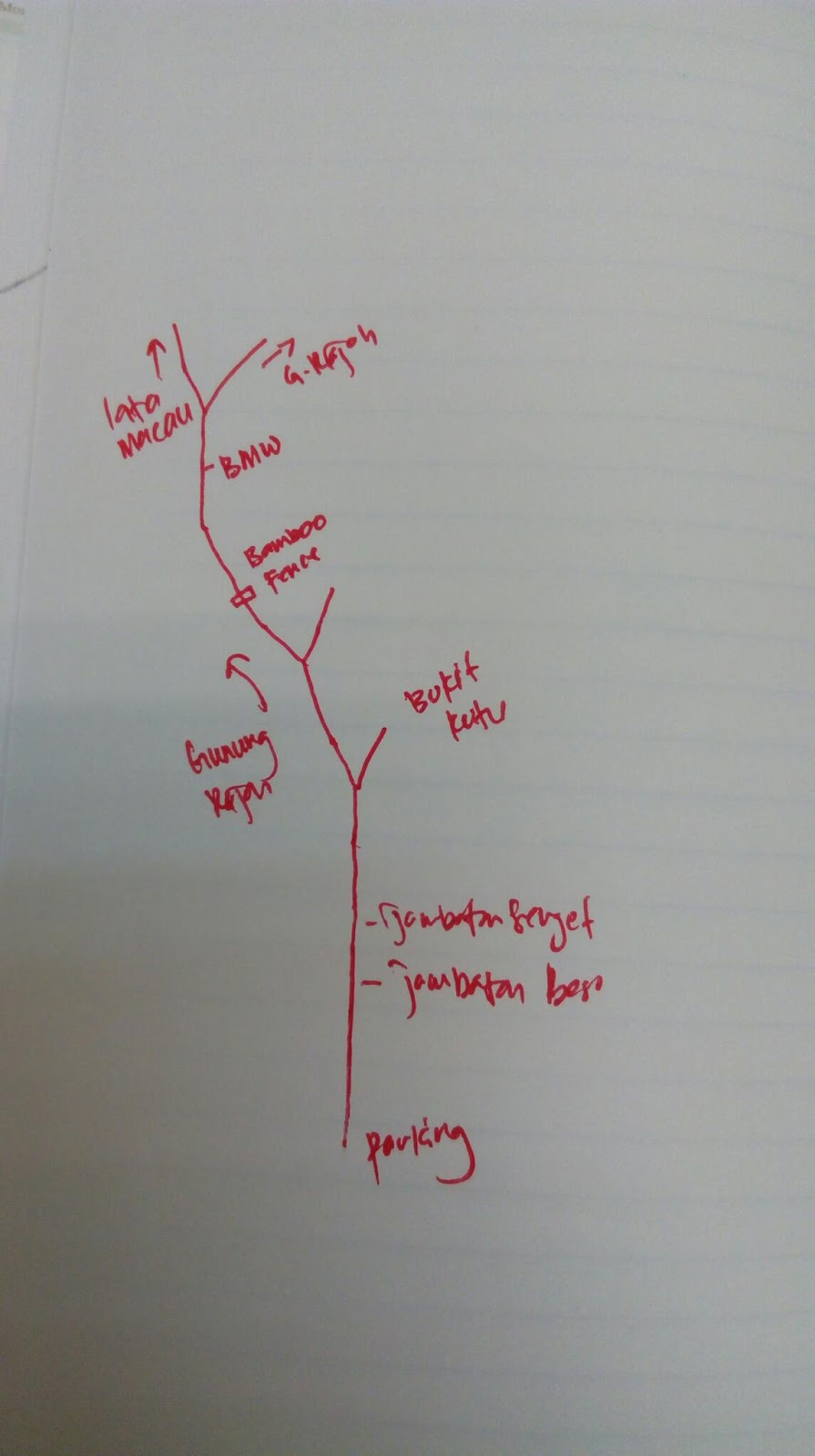
This is the sketch of the direction
Thanks for reading.
nice. thanks for sharing your hiking story. thinking of hiking the hills n mountains which ive never been. hows the gps n phone coverage over there?
ReplyDeleteThanks. Intermittent coverage at certain section for telephone line. GPS coverage is good. The mountains are calling
ReplyDeleteboleh sent file gpx bro.. tq
Deletebro, share file GPS bole. thanks hehe. opfarhan@gmail.com
DeleteLeh share link gpx? Thanks.
ReplyDeleteSent...hehe
DeleteHi,
ReplyDeleteCan i hv the GPX? If ok, please send to ksw_1999@hotmail.com. Thanks.
sent...
Deletethank you for reading
can i also have a map
ReplyDeleterezalismail@gmail.com
tq
gpx file sent
DeleteThank you for the info
ReplyDeleteno problem bro. Harap dapat naik dan turun dengan selamat.
DeleteHi. From kkb, still need permit and guider? esprit220@hotmail.com
ReplyDeleteNo need...but it's better if you go in groups to be save.
DeleteHi...can i get GPX file.
ReplyDeletesiewyeeying@gmail.com
thanks in advance.
gpx sent via email
DeleteAsSalam boleh sent file gpx ? muhaimin1st@gmail.com tqvm :)
ReplyDeletegpx file sent
ReplyDeleteCan send me gpx file.. Faizal.mohd8381@gmail.com
ReplyDeletegpx file sent
DeleteSalam. Bro boleh send gpx file? Tq in advance :)
ReplyDeletezairulzainol@yahoo.co.uk
gpx file sent
Deletebro minta tlg sent file gpx
ReplyDeletesimsarol.hmbo@gmail.com
or simsarol_mnse@yahoo.com
tlg ye bro, sbb igt nak naik sabtu ni
gpx file sent
Deletebro. mintak tolong sent gpx file. thanks
ReplyDeleteqamarulbazli@gmail.com
gpx sent via email
Deletehi..kalau xpkai gps track dia jelas x? marking byk x?
ReplyDeleteTrack dia clear, marker pun banyak, kalau boleh bawak la plastik marker tu, so, boleh tolong tambah utk hikers lain. Jangan risau. Semoga berjaya
DeleteAssalamua'laikum. Agak2 klo hiking sorng2 blh smpai?
ReplyDeleteTak recommend bro kalau nak pegi sorang2 sebabnya in case kalau terjadi apa2, hilang ke, pewai ke, sesat ke...line telephone susah sikit kat situ. At least 2 atau 3 orang la utk selamat. Tapi kalau nak redah gak sorang2, boleh...track dia clear, marking semua ada. Saya ucapkan terima kasih pada org yg pasang marker ni
DeleteWill you send GPS file? Thank u in advance.
ReplyDeleteaycook@hotmail.com
GPX file sent. I wish you save journey
DeleteHi pls send GPX file to my email at asgoh88@yahoo.com...tq very much
DeleteGPX sent - 5/9/2016 at 9.25am
DeleteAssalamualaikum....blh share GPX file..wafi143@gmail.com
ReplyDeleteTerima kasih....
Walaikumsalam...sudah email pada 7 Sept 2016 pukul 9.07am. Semoga pergi dan pulang dengan selamat.
Deleteالسلام عليكم.
ReplyDeleteBoleh share gpx trail? Trm kasih
mad_zee90@yahoo.com
salam tuan, gpx map sent at 10.10am, 13/9/2016. Semoga berjaya naik dan turun
Deleteterima kasih info berguna bro. boleh share gpx? terima kasih
ReplyDeletegpx sent on 14/9/2016 at 9.10am.
Deletesemoga selamat mendaki naik dan turun bro
Thanks for the information bro ijam. Im interested and planning to go there next month. Can share with me the gpx to muhd.firdaus.othman@gmail.com.
ReplyDeleteAppreciate and thanks in advance.
Thanks for the information bro ijam. Im interested and planning to go there next month. Can share with me the gpx to muhd.firdaus.othman@gmail.com.
ReplyDeleteAppreciate and thanks in advance.
dah sent on 26/9/2016 at 9.36am tapi email tu bounced lah...
DeleteHi can send GPX file to me as well.
ReplyDeletemr_mohdfitri@hotmail.com
file had been sent on 27 Sept 2016 at 3.15pm. Good luck
Deletecan i have the gpx as well, hunkok@gmail.com, thanks
ReplyDeleteDear Mr HK Loo, gpx file sent on 7/11/2016 at 5.58pm. Have a safe journey
DeleteHi, boleh x send gpx ke Subhanallah_1@yahoo.com. plan nk gi this sunday 3.am.
ReplyDeletesudah di email pada 15/11/2016 pukul 12.00pm. semoga selamat naik dan turun
DeleteHi sy dan kawan bercadang utk ke sana weekend ni. can I get the gpx file d069392@siswa.upsi.edu.my
ReplyDeletesorry lambat. dah email on 24 Dec 2016 at 3.12pm. Semoga selamat naik dan turun.
DeleteTerima kasih atas perkongsian ni!
ReplyDeleteada sumber air tak sepanjang route tu ? in case of emergency..
ReplyDeleteMr Jack, masa mula perjalanan tu lebih kurang beberapa kilometre ada sungai. Half of journey ada air.
DeleteHello bos..any permit required?
ReplyDeleteAs far that I know, no need. Hoping for safe return ya
Deleteidolaaa......
ReplyDeleteaiseyman...nasib baik tak tau sapa. Yolah...semoga selamat naik dan turun
DeleteHahaha.. xpe, yg penting awak idola kita... Next time jgn lupa ajak k bro. Hahaha
Deletehi,
ReplyDeletecan you share the gpx please.
hiking.tracks@yopmail.com
Thanks in advance 😄
gpx file emailed on 24 Feb 2017 at 9.16 am. Safe journey ya
Deletethanks a lot ijam
Deletei completed the hike on 26th Feb
hi Ijam,
ReplyDeletecan you share the gpx please.
my email is pavarit_cheer538@hotmail.com
many thanks.
Sorry for the late reply. Sent on 3 March 2017
DeleteHi..
ReplyDeleteCan you share gpx file please..
Here is my email, adienzo18@gmail.com..
TQVM..
Sorry for late reply. GPX file sent on 3rd March 2017
Deletehi pls may i know what model of your watch? thanks!
ReplyDeleteMr Jason, I'm using suunto ambit 2, few years already. Now they have new model, ambit peak, traverse - which have more function
DeleteHi..
ReplyDeleteCan you share gpx file please..
Here is my email, dic1813@yahoo.com
..
TQVM..
Dear Dicky Mok, gpx file sent on 11 April 2017 at 9.15am. Safe journey ya
Deletewow, nice journey!
ReplyDeletecan send gpx map to me at lipkarheng@gmail.com ?
TQ so muchhhhhhhhhhhhhh :)
email sent on 29 oct 2017, sorry for the late reply
DeleteHi, Boleh sent gpx gunung rajah via kkb?
ReplyDeleteerr..kasi email bro, baru boleh hantar
DeleteHi Mr Ijam.your blog is informative & fruitful for me.planning to hike this weekend.can you please email me the gpx?this is my email sasi.1682@yahoo.com.thank you.
ReplyDeleteemail sent on 29 oct 2017, sorry for the late reply. safe journey ya
DeleteHi mr ijam.. boleh send file kpd sy juga? Thanks in advance. ijoi_88@yahoo.com
ReplyDeleteemail sent 29 oct 2017, sorry for the late reply. safe journey ya
Deletehi en ijam,,can u send me the gpx file to my email..fakhrulakmal1612@gmail.com..tq in advance
ReplyDeletedah email, on 9/8/2018, sorry blog tak kasi alert pasal comment ni
Deletesalam. mintak share GPX file. email mohamadashrafrusli@gmail.com. terima kasih
ReplyDeletedah email, on 9/8/2018, sorry blog tak kasi alert pasal comment ni
DeleteSalam encik Ijam, boleh saya dapatkan GPX file.
ReplyDeleteaiz91.aw@gmail.com
thanks in advance.
dah email, on 9/8/2018, sorry blog tak kasi alert pasal comment ni
DeletePakchik tertinggal bas ni. Hehe. Mohon send gpx file ke zonhisham@gmail.com
ReplyDeletedah email tuan
ReplyDeletereceived with thx
ReplyDeleteAssalamualaikum tuan, boleh sent gpx gunung rajah via kkb? areniece79@gmail.com
DeleteTerima kasih
Assalamualaikum tuan, nak minta share gpx boleh?
ReplyDeletependekar289@gmail.com
terima kasih banyak banyak =)
Saudar Abrar,
DeleteSaya dah email GPX file yg saya perolehi dari Ijam. Semoga selamat naik dan turun.
terima kasih tolong emailkan, terlambat tengok...huhu. Semoga selamat naik dan turun
DeleteThis comment has been removed by the author.
ReplyDeleteSalam k
ReplyDeleteThanks for the post. It was informative.
But I think there been minor changes.
Most important water point is now called R&R kem
Also added to more signs for camp potol and other one I forgot it's name.
You should also mention that it's very hard to do in one day. Everyone I met on my way was camping and they did it in 2 days I think.
Wah, thanks so much on the update. I also believed that the route can be access by other nearby trail as well, just twist and turning. Nevertheless, a lot have changed and thanks for the information
DeleteSalam, nak mintak share gpx file boleh tak? - muhammaddanial27@gmail.com
ReplyDelete.
.
Thank you!