
Conquering Mount Tahan in 9 hours was a grueling climb that had pushed 16 of us to the limit. Starting from Sungai Relau
(Merapoh) at 9.15am and reached the peak 9 hours later (6.12pm) was one thing
we could possibly never imagine. Crossing 8 rivers with wide,
thigh deep and risk being swept away by the strong current, stretching your leg
muscles with a series of endless uphill, descending in a pitch black forest
with our head lights, braving the rain for hours all the way down with muddy trails,
cold and wet all over and rumors of ghoul and wild animal on the trail put us
on a scary shit.


Stranded at Kem Luis for hours
due to rising water level prevented us from crossing over at 3.00am. Moving on a large pack during
descending is a must to avoid any unwanted incident and improved confidence
level. We ended the journey at 7.00 am after 21 hours of sleep deprived. Care
to take a ride?

The brave hikers and guide
Background
Hiking one of G7 mountain is
always been my dream. G7 is a series of mountain in Peninsular Malaysia with a height of more than 7,000 feet. There
are 7 mountains in total : Gunung Tahan (7,186 ft), Gunung Korbu (7,162 ft),
Gunung Yong Belar (7,156 ft), Gunung Gayong (7,129 ft), Gunung Chamah (7,210
ft), Gunung Yong Yap (7,110 ft) and lastly Gunung Ulu Sepat (7, 089 ft).
Gunung Tahan, being the toughest
and hardest of all, standing 2,138 metre, will push your mental and physical
strength. There are several routes used either via merapoh or Kuala Tahan but
the most popular one is via Merapoh i.e Merapoh – peak – merapoh.
I drove from KL to Sungai Relau
Taman Negara Merapoh, 12 hours before the hike. Slept in my car at the administration office’s
compound. The rest of the gang scattered around sleeping near the gazebo.
It is compulsory for 4 x 4 to transport
you from Sungai Relau to Kuala Juram (15km), its in the package. Later, on the
day of your return, they will pick you up at your target date and time, please
refer to your guide for arrangement.
There are No phone signal
transmission at Sungai Relau office and Kuala Juram, please update your loved
ones 5km before entering sungai relau which is at the main road. Its a dead
zone here.
Sungai Relau office is complete
with toilet and water supply – prepare your things here. You may find a signage
for mobile phone signal available while on the climbing track.
Before Hike -Training
Training will concentrate on leg
muscle, long hours and simulation 2 months before the hike. Gunung Nuang to
Peak – 2 times. (Gunung Nuang) Pangsun– Peak – Janda Baik – Peak-Pangsun (11
hours). Bukit Saga-Peak-Bukit Apek Peak-back to Bukit Saga – 3 times. Gunung
Nuang to Kem Pacat – 1 time.
Yes, the training improves me a
lot.
Gear Used
Cap, Drifit Tshirt, 3 quarter
tight, running socks, Brooks Cascadia 10, suunto ambit 2 wrist watch
Deuter Speedlite 20Litre backpack
Mandatory item : drinks 2 litre,
emergency blanket (RM5), Lighter, Head light (with extra battery)
What else in the bag : 700ml
plain water in soft bottle, coke 700ml, thin sleeping bag (RM50), bag rain
cover, power bank, handphone with cable, suunto watch cable, empty plastic bag,
heat cream, band aid, panadol, power gel 2 pcs, water filter tube (to filter
mountain/river water in case of emergency).
Food supplements : 2 sets of egg sandwiches,
2 pcs of bread, 5 pcs of bread with margarine and kaya (sweet coconut paste),
red apple – that’s it.
On The Way to Sg Relau
Sungai Relau (about 394km from
Kuala Lumpur – almost 4 hours journey) is a location whereby all registration,
declaration of items and completion of forms need to be done one day before (close
at 4.30pm) actual hike. Luckily I have En Arman to help us to declare on that
day. I handover the hiking bag plus the items to him before hand (thanks
Arman).


Having tips from otai

Ample parking space


The gazebo and toilet are in the background


The entrance to Kuala Juram, Our 4x4 vehicle will go through here

The entrance to the office

Nasi lemak for breakfast, nasi with lauk for lunch

Those who ordered breakfast and lunch, please collect here

Ishak, Man Abd Shukor and Syed having their best breakfast of the day
The night before, we were
informed that the hike will start at 8am. Not as I expected for. I have to
re-evaluate the risk that we will return back to Kuala Juram by 2.00am!
The Day of the Hike
The 4 x 4 should reach around
8.00am to bring us to the starting point i.e Kuala Juram. However, they arrived
30 minutes after. Delaying the hike, will also delay our return time...adui.
There were 7 of us in our group Arman, Man Abd Shukor, Ishak, Jawa Terakhir,
Syed, Ghazz and myself. Another 9 hikers were from different group.
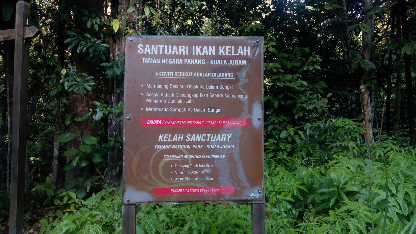
Kuala Juram
We reached Kuala Juram around
9.00am (15km journey). Kuala Juram is some sort of small village complete with
surau, toilet and few small halls (I don’t think there is electricity for us to
use here). It is also a Kelah (type of fish) sanctuary (complete with CCTV) –
the fish is protected. This is a starting and ending point. We will spend one
night here as planned while waiting for the 4 x 4 the next day at 9.00am to
transport us back to Sg Relau. We started hike around 9.15am, 16 of us with 2
guides. Ustaz nan (one of the guide) made a final briefing and pray for 10 minutes.


This is Kuala Juram

Nice and Tidy

This is the surau where we put our necessary items for an overnight

The hall

The toilet (no lights ya)

Kelah Sanctuary


The briefing
Few Key points on the distance to summit
According to website www.tamannegara.asia , there are 8 check
points we need to pass thru and the distance indication from each other.
Below chart is a comparison for each
distance with my suunto ambit 2 wrist watch.
Check Point Name
|
Advertised
Distance
|
Suunto Ambit 2 distance
|
Suunto duration and time of the day
|
Duration Took from each check point
|
Kuala Juram to
Kem Luis
|
5km
|
2.91km
|
1.1 hour –10.16am
|
1.01 hour
|
Kem Luis to Lata
Luis
|
6km
|
No data (forgot to
check, damn it!)
|
||
Lata Luis to Kem Kor
|
2.5km
|
5.64km (from
starting point)
|
2.08 hr (from
starting point
11.24am
|
1 hour 7 min
|
Kem Kor to Permatang
|
2.5km
|
4.57km
(7.07km from starting point)
|
3.17 hr (from
starting point)
12.33pm
|
1 hr 9 min
|
Permatang to Kubang
|
3.5km
|
4.19km
8.76km from starting
point)
|
5 hour (from
starting point)
2.16pm
|
1 hour 43 min
|
Kubang to Blumut
|
1.5km
|
No data (forgot
again)
|
||
Blumut to Bonsai
|
5.5km
|
12.2km (from
starting point)
|
7.32 hr (from
starting point)
4.47pm
|
2 hr 31 min
|
Bonsai to Bukit
Botak
|
3km
|
No data (forgot
again and again)
|
5.30pm
|
1 hour 17 min
|
Bukit Botak to Peak
|
2.4km
|
997metres
(14.93km from
starting point)
|
9 hours (from
starting point)
6.19pm
|
42 minutes
|
Total
|
31.9km
|
14.93km
|
9 hours
|
The measurement according to the
website is 31.9km one way, however, Suunto ambit 2 showed 14.93km one way. One of our group member, en Khalil's suunto recorded 35.78km for the whole journey i. e 17.75km one way . Well,
since the route already programmed in my suunto, might as well I follow it. And
it was correctly measured...I mean the suunto. So, follow the Suunto my friend (I might be wrong...).


Hiking & Trail Condition
Kuala Juram to Kem Luis
Easy trail, crossing rivers –
piece of cake
Kem Luis to Lata Luis
Easy trail, crossing rivers –
piece of cake
Lata Luis to Kem Kor
Moderate trail – starting to feel
tired


We are now at Kem Kor - 5.64km from Starting Point
Hardest – uphill all the way,
muddy trail, technical as you may used all your core muscle, getting fall is
easy at this stage as you are tired.

At Permatang Check point

At Kem Kunbang - the trail up to here is muddy and tough

Hard – uphill all the way, muddy
trail, the air is getting thinner, more open space, you can see series of
mountain surrounding.


Descending at Night


Mount Tahan in 9 hours!!
Descending at Night
We started descending around
7.30pm, its getting dark. Some scary shit wild animal will hunt at night
(hikers are prohibited to bring knife, when encounter with a tiger, just use
your fist). Putting on our head lights and move on. The trail was very-very
slippery. I fell countless times and as a result, there were few bruises all
over my body. The head light only limit to lite up certain focus area in front
of me, you may need to be extra careful. Thick fog will be present, it will
also dampen the visibility but not that serious.
At 3.00am, we reached Kem Luis,
unfortunately the river water level has increased preventing us from crossing
over. We need to wait for the water to subside. Slept for 1.5 hours here. It’s
cold sleeping on the soft ground. I pull out my sleeping bag (very thin, water
proof, size of your palm when folded – I don’t know what it is called). I put
on my handphone’s flash light the entire sleep. The rest of the hikers switch
off their head lights to conserve battery.
All hikers except 2 (I think)
have reached Kem Luis during this 1.5 hours. At 4.30am, woke up by Arman, we
wanted to cross the river and it looks like the water level has subsided. After
successful river crossing, it is time to walk, hike, cross river some more to
Kuala Juram, situated 2.9km away.

Jebat (red shirt) and Khalil (yellow shirt) are so powerful hikers
Met Pak Syed Al Baiti at Kem Kor.
There were a lot of campers that night. Fatigue, no energy, hungry, sleepy,
disoriented at some point – were some of the results from the hike.


Sleep deprived - having breakfast
Finally, at 7.00am we reached
Kuala Juram and its getting bright already. Washed up, had our breakfast and
headed home.

Declaration back

Part of the items in the declaration
I am self declaring that we have conquered Mount Tahan Daypack in 21 hours....yay!!