
should capture the volcano on the left....demm!!
 It should be like this having the volcano at the background. Photo by Jaz Jerry.
Thanks man

Thanks man

Overlooking the mountain on Lombok
We arrived at Lombok airport around 9.30am and our chartered van were ready to transfer us to Sembalun village, the journey took around 3 to 4 hours.

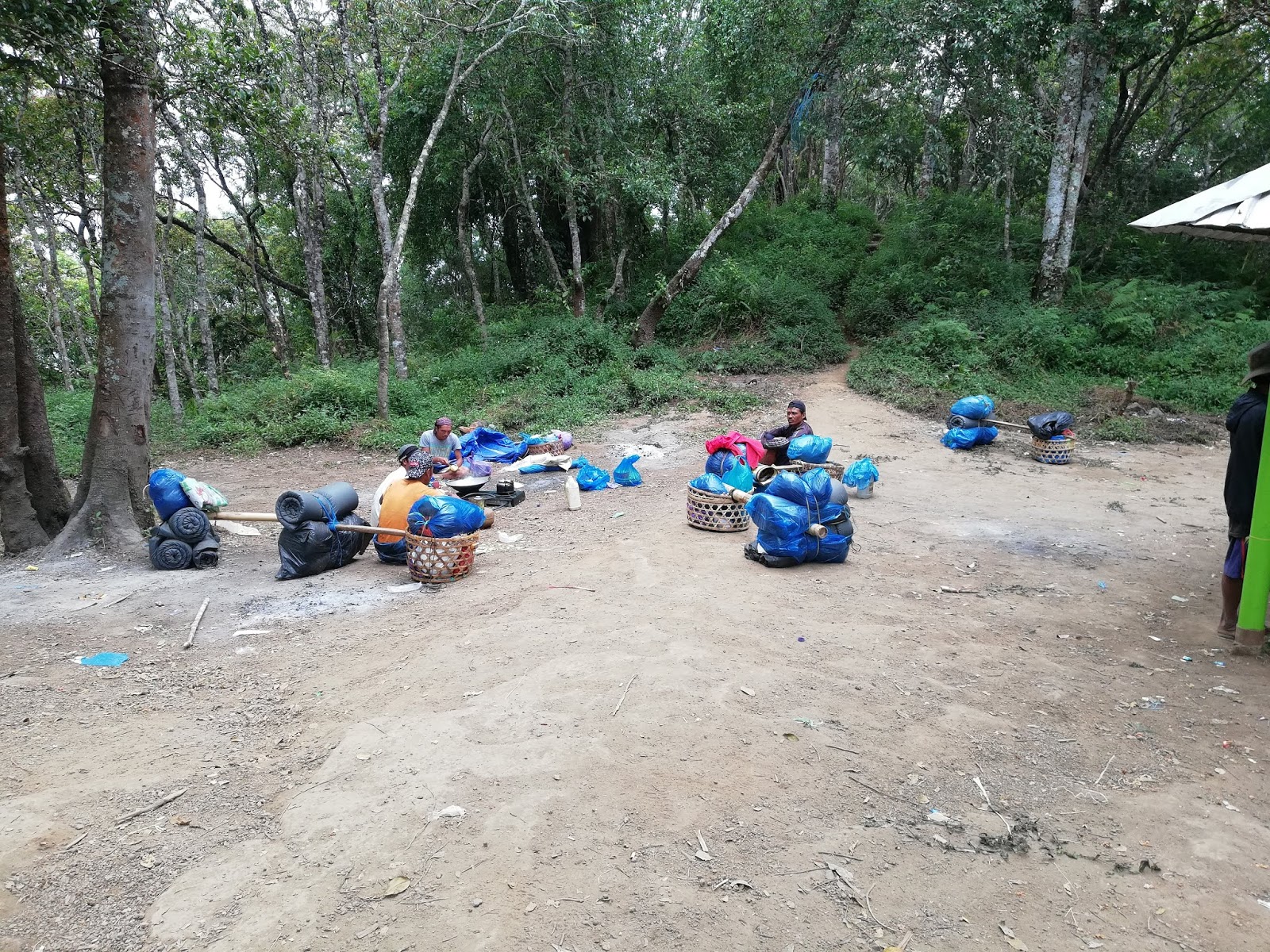
Stop here for brunch...the bird was small and hard...but the rice and condiments are superb!

The team of powerful hikers
There are 2 popular routes for hiking mount rinjani i.e via
Sembalun and via Senaru. Both have their own set of challenges but the most
popular is via Sembalun as the route are more scenic with proper water points
while via Senaru, there are less view and will find difficulties on the water
point.

this is at Taman Wisata Pusuk Sembalun...some sort of look out point to enjoy the view

The view is ..mesmerizing

Our trustworthy van...
Most of Rinjani’s hiking operator will have 4 days 3 night
package, which we will follow that, however, it can be modified to cater for
faster hiker according to our needs :
1) Option 1 (standard package – 4 days 3 Night)
Day 1 - depart via Sembalun – overnight at POS II
Day 2 – depart from POS II – overnight at Pelawangan
Day 3 – Summit Attack from Pelawangan then to Tasik Anak
Segara (overnight here)
Day 4 – From Tasik Anak Segara to Senaru
If you’re a faster hiker, you may opt for the 2nd
option :
2) Option 2 – 2 days 1 night
Day 1
9.30am from
Airport, Depart straight to Sembalun village
12.30pm – reach
sembalun village and lunch
2pm – start
ascending from Sembalun to Pelawangan – overnight at Pelawangan
Day 2
2am – summit
attack
9am – reach back
at Pelawangan
10am – start
descending to Senaru
3pm – reach Senaru
Done hiking. But
may extend another night at Lombok before flying back to Malaysia.

Drop off zone...at our homestay in Sembalun

Preparing the gear...just bring only what you need

Mount Rinjani at the background....within reach but yet sooooo...far...

Belum siap-siap lagi ke oi!...banyaknya packing
Here is our journey
in conquering mount rinjani within 3 nights :


This will be the scheduled plan - day 1, 2, 3 and 4, at which point where we will be
Day 1
Depends on which part in Sembalun to be the starting point,
the distance are more or less around 3km – 4km from Sembalun village to Pos I.
We decided to hike straight from Sembalun to Pos 2 which is
around 5km or so which took us about 3 hours 30 minutes.

8.30pm we reached Pos 2. Don't bother about the distance as I forgot to turn it on..huhu
Sembalun Village to POS I – 3km – 4km
Trail difficulty : easy
Trail Condition : dry, dust
Duration taken : forgot to record (damn it!)
As we hike at night, there wasn’t much to see, even we
didn’t realize that we have passed Pos 1. huhu

At Pos 2, this will be the water station. It had been filtered to produce a clean and clear water

*POS I to POS 2
(camping at POS 2)
Distance from POS I to POS 2 : 1.4 km
Duration taken : forgot to record
Distance from Start : 5.4km
Trail difficulty : easy ascending
Trail Condition : dry, dust

Our tent facing mount rinjani

The're ample space to set up the tent and it is a popular spot for camping while admiring Rinjani's beauty.

At most of the Pos (check point) there will be stall vendor like this. Instant noodle,
carbonated drinks, hot drinks...but no ice...have a try, support the local to make ends meet.

From Start straight to POS 2
Distance from Start to POS 2 : 5.4km
Our porter was infront of us all along, hence, they already
prepare the tents and cooking for dinner.
There is one more option to get to Pos 2 the fastest
way…riding a motorbike known as Ojek according to the locals. 3 of our team
member opt for this as they scheduled to come a little bit later which is on
the 2nd day to be with our team.

Yup...ready for Day 2 from Pos 2 going straight to Pelawangan Sembalun aka crater rim

High altitude breakfast...prepared by our porter

21 of us (3 had just join us on 2nd day, another one will be joining us the next day)
Wohoo...bring it on!!
Day 2
POS 2 to POS 3
Distance from POS 2 to POS 3 : 1.7km
Duration taken : 1 hour (from 8.10am - 9.10am)
Trail difficulty : moderate hard ascending
Trail Condition : dry, dust
Distance from Start ; 6.1km


Its like a very slow ascending in a hot sun

Its like a scene from a savannah movie or something

Having a breather at one of the mini check points. I can see Sembalun valley from a far
POS 3 to Pelawangan
Sembalun (Camping at Pelawangan Sembalun)
This check point also known as Crater Rim
Trail difficulty : hard, long climb and scorching hot!
Trail Condition : dry, dust
Duration taken : 2.16 hours (9.10am – 11.26am)
Distance from start : 9km

We reached here at 10.05am, almost 2 hours from Pos 2. Switching off the gps recording to conserve battery...which I will regret later...

Climbing up to Pelawangan Sembalun leaving the rest area hut

My selfie doesn't cooperate well with the background scenery

Nice view...yes, it is up, up and up


Finally we reached top of Pelawangan Sembalun....but not just yet...another few hundred meters to our camping site. This will be some sort of transition area whereby hikers will camp overnight, went on climbing that crazy altitude rinjani, going back down here, then exit to Senaru. Oh yes, on the right of the photo is the trail down to Senaru.


Once up here, turn on your left and go straight to rinjani's peak

11.44am and it is time to rest - 3 hours 44 minutes from Pos 2. We are far away ahead of our guide, as he is waiting for other team member
As we go straight, we reached the 2nd camping area. Please be mindful of the "fall of death into the abyss" section on the left and right.
 Surprisingly, we met Pak Syed here who just came down from the summit - 2nd from left.
Pak Syed is a well-known person in hiking community of his activities and hiking trips.

Pak Syed is a well-known person in hiking community of his activities and hiking trips.
Estimated there were hundreds of climbers including porters and guides camping here.

Silhouette time....as the sun goes down...there were many hikers admiring the sunset. Except the porter and guide la...they have been here many times, too many sunset and sunrise.


"Cloudy with a chance of raining meatball"
Day 3
Pelawangan Sembalun to Rinjani Peak
Distance from Pelawangan to Rinjani Peak : 3km
Distance from Start : 12km
Trail Difficulty : extreme Hard (less oxygen)
Trail Condition : dry, dust, loose sand, gravel
Duration Taken : 4 hours (2am – 6am)
Temperature : less than 10 degree
Tips : use trekking pole to keep balance and easier to move
your body forward
We started in a slow pace climbing up the mountain, there were many climbers started at the same time, as such, bottle neck section is everywhere. Climbers will stop to catch a breath, to wait for their team member, guide also will stop & wait for their client, and some of the climbers also stop to sleep at anywhere that they feel comfortable.
One thing becomes a challenge during the climbing is the dust from the loose ground. On each step, the dust will emerged, mostly invincible and you just have to suck it up. I have to endure the situation from bottom to the top as I'm not wearing face mask. Lesson learnt to wear face mask next time...
Challenge number 2 - Cold Wind during hike. The temperature at the top around 10 degree according to my suunto ambit watch. The wind will continuously blazing through and my 2 layer cotton tshirt and a down jacket wouldn't hold in a longer period of time as I'm shivering. So as my finger.
Challenge number 3 - Thin Air. At altitude of 3000 meters, the're very minimum of oxygen in every breath that we take. I admit that I'm having difficulty in breathing and keeping my hiking momentum, thus, I've being forced to catch a lot of breath and a lot of stops. That's the way to manage it.

According to this chart, only 13.5% of the air that we breathe is oxygen. Imagine how powerful our heart need to pump those oxygen in. If it doesn't enough, Altitude Mountain Sickness (AMS) will struck due to lack of oxygen. Dizziness is one of common symptom.

anyway, our group managed to the top. Yes!


Photo taken nearly to 7.00am, the sun is up, revealing the path that we came from.
Rock and sand. Look at the background...wow!

Other hikers are still struggling inch by inch climbing up.
The loose sand will keep on sliding down on every step, consuming more energy

It is only 300 meters or less to the top from here. The longest 300 meters I've ever had that morning.


Pelawangan Sembalun (crater rim) to tasik Segara Anak
Distance : 4 km
Duration take : 1 hour 38 minutes (2.38pm - 4.18pm)
The lake that we used as a background in our nice photos are the same lake here.
We didn't stay long at the top as I'm not really adapting the cold temperature and I can't feel my finger. We make our move 'sliding' downhill with few clumsy falls...its fun! On the way back we met with fellow team members at few locations and encouraged them to don't give up.
The sun was starting to get harsh during the descending and 3km and 1 hour plus later, we reached the camp. Time to take a nap while waiting for others to return.
There are water source here, but you need to walk a bit, climb a bit around 200 meters from our tent.
The water is magically come out from the rocks, its cold and refreshing.
We continued our journey around 2.30pm after all team members have returned. Down we go to Senaru.

Going back to Senaru. On your right is the way it should be.
Yes, there are local vendor selling food and drinks here.

Let's have a speed walk down to misty trail below

Admiring the porter - please give way whenever you come across them

Hanging bridge

4km and 2 hours later, we reached Tasik Segara Anak, a popular camping ground.

Its a beauty!


From 2.30pm to 4.21pm

Suunto Ambit with Volcano at the background

Piece of cake to here. Once again, I should focus the handphone to the background


The water is ok to swim but not ok to drink without boiling it first. It tasted like gun powder.

Abang Rosli in trying his bet to catch the fish


This is the other part of Tasik Segara Anak, on the way to hot spring and water source point.
There is also a water fall.


People will flock here for hot shower or take fresh water

It's one hell of a journey to bath and take fresh water but its worth it

This way to fresh water, get yours now

The hot spring - its a small but sufficient. Its not that many people. Photo taken from google


Our camping area overlooking the mountain. Stunning view
We have 14km in distance to Pintu Senaru with heavy inclination on the first 3.5km. Please take note on this as sometimes you will be informed of heading to Senaru is all the way down...yeah right.
We started by walking at the edge of the lake. Then heading right towards the hill. What a hill it would be with inclination all the way.
Day 4
Tasik Segara anak to pintu Senaru (finishing point) - 5 hours, 14km.
The distance can be divided into 2 section – part 1 is the ascending and part 2 is the descending

Part 1 – from Tasik Segara Anak to Pelawangan Senaru
From Tasik Segara Anak the trail is flat and just walk around the lake until we reach a section whereby it is the beginning of the hike. It was a crazy hike, estimated around 3km long hard climb to top of Pelawangan Senaru.


"I'm on the edge, of glory"

One shot at the lake
It took us around 2 hours for 4km hike from Tasik Segara Anak to on top of Pelawangan Senaru.
Tasik Segara Anak to Top of Pelawangan Senaru
Distance : 4km
Duration : 2 hours
Trail difficulty : hard climb
Trail Condition : 70% rocky terrain, 30% small trees, grass
Then, from top of Pelawangan Senaru, it is all the way down until pintu Senaru finishing point

Over contrast photo

Yummy inclination...


The porters are everywhere so no need to worry if you got lost somewhere. Just ask them, they will assist you

Tough job

Tough job requires constant smoke break

Bapak punya cantik!!


Muka Pewai...bila nak sampai oi!

At one of the section


Traffic at a one way section

The safety bar that help us all along

Finally, a few hundred meters more

The white pole thingy - its a beacon...i think

An award winning photo for today for successfully completing part 1 of the climb

I forgot to take photo of the time we reached top of pelawangan senaru but estimated around 10am, 2 hours from Tasik Segara Anak
Part 2 - From Top of Pelawangan Senaru to Pintu Senaru
Distance : 10km
Trail difficulty : easy
Trail Condition : 20% open space, 70% dense forest. Loose sand at the beginning of ascending – dust alert!

Rocky surface

If you look closely, I'm using a tree branch as shelter...ok not funny

Becareful of the steps ya..

One of the rest hut when we descended down

Yes, the countdown begin....This is Pos 3 of Senaru link (don't be confused with Pos 3 sembalun when we first came on our day 2 ya - it is on different route)

around 40 minutes of fast descending to here. 11.09am


11.54 at Pos 2 . Approximately 1 hour to here


28 minutes to pos Extra. another 1.3km to Pos 1


Forgot to take the time...demmit!


Personal glory. Somehow I enjoy downhill rather than uphill.

Wohoooo....Done! From 8am to 1.15am, Distance 14km in 5 hours.

Our homestay around 20 minutes walking from Pintu Senaru, less than a km

Yay! Dah Sampai..
We say goodbye to Rinjani with a heavy heart. There are so many memories and experience, not to forget the astonishing scenery of mountain - volcano - lake. Its so picturesque!
A little advise for those attempting rinjani for the 1st time or for the sake of your revenge or whatever, please train hard - long, hard climb, practice those leg muscle for a tough impact.
Hope to see you soon Rinjani.
No comments:
Post a Comment