Mount Yong Yap, Bubu and Tok Nenek popular known as YYBTN
will be our target since the completion of our V1 in 2016 (V1 – Mount Korga,
Junction and Yong Belar).
Yong Yap : 2167 meter (G7)
Bubu : 1974 meter
Tok Nenek : 1916 meter
Yong Yap : 2167 meter (G7)
Bubu : 1974 meter
Tok Nenek : 1916 meter
Our mission initially was to conquer V2 (Yong Belar,
Junction, Korga and YYBTN) but later reduced to V1.5 after climbing one third
of the journey and being reduced to just YYBTN soon after.
Though our suffering being reduced to ease the pain which
was later being blessed by making the right decision not to proceed with
neither V2 nor V1.5.
Our teams were divided by 2 teams with 6 climbers in each
group including with one guide. Group one consist of 6 young lightning fast
pace and the 2nd, consist of the veterans – myself, wak Jawa, bro
Ghazz, bro Rino Irwan and our guide, Am. Arman Arshad was supposed to join us
on this trip, however, he bailed out due to work commitment.
Group one
Group 2
It had been raining days before the hike in Cameron Highland
and we were preparing for that. Our journey was supposed to start from Yong
Belar, however, changed to Yong Yap as we calculated the risk that Yong Yap
route will require a lot of river crossings and we will face these challenged
at earlier stage as the rain which normally occurs in the evening and all the
troubles such as stranded due to water rises or endangering ourselves while
crossing the river can be avoided.
Mount Yong Yap will start at Sungai Rengil which would
require a 4 wheel drive. 20 minutes journey from Kampung Raja.
The road leading to orang asli settlement in Sg Rengil is properly resurfaced with tarmac road and hikers may park their car at the entrance before the bridge (i think need to pay minimal parking fee).
The road leading to orang asli settlement in Sg Rengil is properly resurfaced with tarmac road and hikers may park their car at the entrance before the bridge (i think need to pay minimal parking fee).
Day Before Hike
Fetched bro Ghaz and headed to Cameron Highland – Kampung Raja
on Friday late evening to prevent a massive crawl due to Chinese new year the
next day.
Met with our Guide, Mr Am at masjid Kg Raja during our
Maghrib prayer and later having our dinner at nearby restaurant.
Hike Day
Parked our car at Sekolah Kebangsaan Kampung Raja (RM10
parking fee) and hop on the 4 wheel drive to sungai Rengil. We started around
6.30am in a cold, misty Saturday morning. The faster group had made their moved
instantly while our team continued with a slow pace.
1st check Point – Kem Simpang Y
We reached Kem Simpang Y around 8:58am in 1 hour 56 minutes
at 5.78km from the start.
Kem Simpang Y is some sort of a junction where there were
divided by 2 trails. On the left is a trail to Mount Tok Nenek and the other
trail is to Yong Yap. Both trail will lead you to Mount Bubu and it is like a
‘U’ shape as hikers may decided on where to start and the intended destination
according to preference.
Thigh deep river crossing
Our Guide En Am is an excellent team leader!
Also, both routes may have their own challenges and level of
difficulties. For Tok Nenek trail be prepare to duck and squat – the falling
bamboos will make it harder to pass through.
For Yong Yap trail – prepare for countless river crossings.
2nd Check Point – Kem Agas
We reached here around 11.18am in 4 hours 17 minutes, 11.9km
from the starting point.
Do not face any issue
here. Though little bit of leg sore but manageable.
Distance from Kem Simpang Y – 6km. Time taken : 2 hours
3rd Check point – Kem Sungai Jerok
We reached here at 12.56pm in 5 hours 54 minutes from the
start, 14.97km.
We just can’t believe that we have walked for 15km and yet
there is no sign of hard climb.
Distance from Kem Agas to Kem Sungai Jerok : 5km, Time taken
: approximately 2 hours
4th Check point – Kem Balak Pecah
We reached here at 2.33pm in 7 hours 31 minutes, 17.37 km
from the start. The trail from here will be difficult. We met Ariff here, it
seems that he was unable to follow the fast pace group and decided to stick with
us.
Distance from Kem Sungai Jerok to Kem Balak Pecah : 2.3km,
time taken : approximately 1 hr 30 minutes
5th Check point – Last Water Point
We reached here around 3.13pm, in 8 hours 12 minutes, 18.2km
from the start.
There are one more water point few meters before we reached
here. Both water point will need 15 to 20 minutes (one way) descending for
water supply.
Distance from Kem Balak Pecah to Last Water Point : 1.2 km, time taken : appx 1 hour 13 minutes
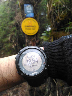
6th Check Point – Bubu and Yong Yap Junction
We reached here at
3.41pm, in 8 hours 40 minutes, 18.54km from the start.
Distance from Last Water point to Bubu and Yong Yap
Junction : 300 meter, Time taken : appx 30 minutes
On the left is to Bubu and Tok Nenek and on the right turn
is going straight to Yong Yap. We put our bags for temporary here as we intend
to hike Yong Yap with less weight. Me, Wak and Ariff were making our way to
Yong Yap peak with only a litre (or less) water as the journey to the peak
estimated around 45 minutes or so.
Mount Yong Yap Summit Conquered!
About 45 minutes (4.24pm), we reached the top of Mount Yong
Yap! Wohoo!..Distance from start 19.25km, we have been climbing for a
staggering 9 hours 23 minutes! Ghaz, Rino and Am followed suit soon after.
After a quick photo session, we headed down back to our bags were. Rested, had
our food (meggi noodles), put our head lights on and ready for our next
challenge – Mount Bubu.
It’s getting dark by the minute in this thick jungle and
Mount Bubu is a long way to go. Drizzling at certain part of the route but we
were glad that there were no occurrence of heavy rain fall.
It was UP, UP and UP!
The ascending slippery and muddy route to Mount Bubu was a
very challenging as we had to climb at night with poor visibility. We need to
be careful of the ground below us as not to fall at any unexpected hole and sky
above us as not to hit our head with tree branch – some will have sharp edges.
Mount Bubu Conquered!
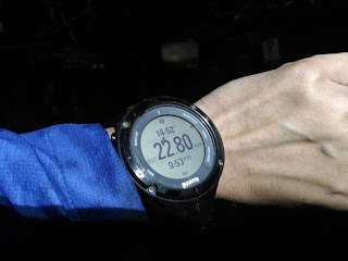
After complaining of when we will get there for thousand
times, we reached Bubu at 9.53pm, 22.80km from start in 14 hours 52 minutes of
climbing. We decided to camp and spend our freezing night here based on our
weak, desperately need to rest condition and somehow it is not safe to walk at
night.
Distance from Yong Yap peak to Bubu : 2.4km. Time Taken : I would say 4 hours (after deducting the
rest time and waiting time)
Spending the Night/Managing the Cold Temperature
I had my 1st layer of Tshirt, Down jacket and
rain jacket – for upper body. For lower body – I only wore a hiking pant and a
long thermal sock. Put my hoodie and my thermal glove on. Sleeping bag is a
must (Karrimor RM90). The only thing that I glad to bring was my carry mate –
some sort of insulation mat. It protected the cold from the ground to your body
while sleeping. I felt comfortable sleeping with the current setting…but not
for long. I woke up in the middle of the night due to extreme cold especially
from my feet and leg. The cold somehow make it way through there. A twist and
turn would not help either. Just bear with it.
The next morning I woke up a little bit early (6.00am) as I
thought we need to start early. But…the rest of the team woke up at 8.00am!
Damn!
On our Way to Mount Tok Nenek
We started our journey around 9.00am, after fooling around
with Rino’s half naked body. It’s gonna be a long and tiring day for us as we
need to be at the top of Tok Nenek and headed down before dark. Or else, we
will spend one more night in the jungle.
The trail from Bubu to Tok Nenek was considered tough with
muddy, slippery and need to use our core muscles to pull us up. It was a clear
blue sky and no sign of rain which make our climb a little easier. I can’t even
imagine if its rain and we have to brave thru those slippery trail.
Mount Tok Nenek Conquered!
On the top of Tok Nenek at 1.00pm (the watch indicated
1.13pm as I am too excited until I forgot to capture the time of arrival). It
was 3.73km from Mount Bubu to Tok Nenek. Estimated of 3 hours and 40 minutes of
climb. The sky was blue. We had 360 degree view of surrounding mountains and
valleys! Wow!
Mount Tok Nenek is famous for its flat, rocky surface. A few
popular photo spots at the edges of the rock. Be careful though as one slip, it
will send you straight down to the endless bottom! Scary!.
Tok Nenek To Kem Belumut
Descending from Tok Nenek was quite challenging due to its
steep and slippery rocky surface.
We reached Kem Belumut at 2.35pm, 5.19km from Bubu within 5
hours 17 minutes. Rested for 30 to 45 minutes here. Having Nasi himpit and Nut
sauce to fulfil my hunger. The trail from Tok Nenek was easy, no more climbing.
We able to speed walk.
Distance from Tok Nenek to Kem Belumut : 1.5km, time taken : appx
1 hour 20 minutes
Kem Belumut to Kem Hari
We reached here around 4.30pm, 7.89km from Bubu after 7
hours 12 minutes of descending.
Distance from Kem Belumut to Kem Hari ; 2.6km, time taken : appx
2 hours.
Kem Hari to Kem Lengkuas
One of the normal check point. Reached here around 5.48pm,
10km from Bubu. 8 hours something.
Fallen Bamboo episode starts here. Around 2 hours or so.
Distance from Kem Hari to Lengkuas : 2.2km , time taken : 1
hour 30 minutes
Kem Lengkuas to Kem Simpang Y (Tok Nenek)
Finally, we reached at the Kem Simpang Y where we came a day earlier – at 7.22pm, 13.3km from bubu in 10 hours.
Our remaining journey is around 6km more to trail head at Sg Rengil. Rested for 5 minutes here.
Distance from Kem Lengkuas to Simpang Y : 3.3km, time taken : appx 1 hour 30 minutes
Kem Simpang Y to Sg Rengil (Finished)
It was an endless walking for 2 hours 20 minutes. Crossing few rivers along the way. And we finally made it! Reached Sg Rengil at 9.36pm, 19.27km from Bubu in 12 hours 17 minutes.
Waited for our 4 wheel vehicle to fetch us and had our dinner at Kg Raja with Eel soup as one of the menu (it’s ghaz favourite)…eww
Total Journey
YYBTN – 42km
Sg Rengil to Bubu (yong Yap and bubu) – 22.80km, time
taken : 14 hours 52 minutes
Bubu to Sg Rengil (Tok Nenek) – 19.27km, time taken : 12
hours 17 minutes


