Suunto...do your magic...
I owned an ancient suunto ambit 2 that had served me many years now. I grew old with that watch.
Suunto ambit 2 or most suunto watches have this function called Waypoints i.e route navigation.
It is a pre-installed route normally in .gpx file that we can download from external sources such as from wikiloc, alltrails, strava or from movescount itself.
*Movescount is a website dedicated only for suunto watches. It's a library of workout we have performed, saved or customized.
In the long run, movescount will no longer be suunto platform as they say it will be replaced by suunto apps - which is a mobile friendly apps.
Ok, coming back to waypoints and route navigation, I used to download,customized and install it to my suunto ambit2 watch. It helped me a lot in finding my way to next point using route navigation.
In other word, you download route (.gpx file), import to movescount, edit, then install it to watch via sync function (using cable, connect the pc to your watch).
However, since my suunto ambit 2 had button malfunctioned (upper right) and 'AD time' (repair centre at shamelin, KL) unable to repair it, so the watch is left idle.
Looking for new watch, Suunto 5 fit my budget and function.
The function that i need to sacrifice which suunto 5 don't have compared to ambit 2 are :
1) temperature
2) compass
Which i rarely refer to but a "good to have" function.
But now with suunto 5, it has tons of function that i couldn't have imagine - just by using your mobile phone.
Setting up
1) install suunto apps to your mobile device
2) pair it with your watch
To navigate a route course - install .gpx file to your phone.
Once it has been installed, add to watch.
The navigation will assist you to navigate the correct way and prevent from getting lost.
Your watch will indicate the total distance remaining, or total distance overall and other features as well.
customization up to 7 fields - i.e up to 7 information you may put under 1 page
However with waypoints navigation, we can customise from point to point - distance remaining, a function which i would die for.
To do this, watch this video on how to install .gpx to phone.
Video on how to create waypoints
This is how it looks after setting up few waypoints (the flag).
The watch will indicate how much further the distance from one check point (flag) to another.
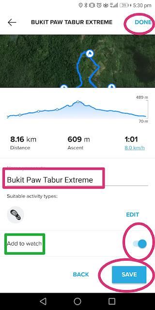
After setting up the waypoints, you may rename the file, save it and add to watch (when adding the route to watch, please make sure your watch is with you, it need to sync).
Once you have setup the watch with navigation route and waypoint, all you need to do is to head on to the starting point and activate it.
Here is how to activate the watch during action
Once the route activated, it will look like this. Toggle the screen (change the screen) by pushing the right mid button.
Hope this helps


No comments:
Post a Comment