
It's a long journey ahead
Summary of Hike
26.9km return (13.7km one way)
6 hours 42 minutes return (3 hours 16 minutes/3 hours 30 minutes one way)
Pre-amble
Bukit Elmo is another rare hill which under the radar.
Not many post via google about this hike, we only managed to put the route into pieces and experience it by ourselves (thanks to Mr Sega and his team).
Bukit Elmo located at the boarder between KL and Pahang.
Hikers can either enter from Janda Baik (Bentong Pahang or Kemensah, KL).
The trail is popular for motocross activity.
For those who had been to Pondok Repin via Kemensah, hiking bukit elmo is easier than that.
The inclination only happened few hundred meters to the peak. Nothing to be alarmed at.
Leeches not many as I got bitten by only two (I didn't see it coming).
Few river crossings that could not be avoided, yes, your shoes will get wet.
There are no trail markers but the trail is clear (I would advise for navigation device as an added assistance).
For those next hikers, appreciate if you could put up trail markers along the way.
Download GPX route file via suunto apps (android) here :

sunnto apps
Or download via wikiloc Here
Wikiloc | Bukit Elmo Kemensah Trail
https://www.wikiloc.com/trail-running-trails/bukit-elmo-kemensah-68503903
Starting Point

Teratak angah GPS coordinate

overall distance at a glance
The starting point
Teratak Angah parking lot


Bukit Roket
Please turn right after this
From Starting point to Bukit Roket - 5.2km

at Bukit Roket - 5.3km from starting
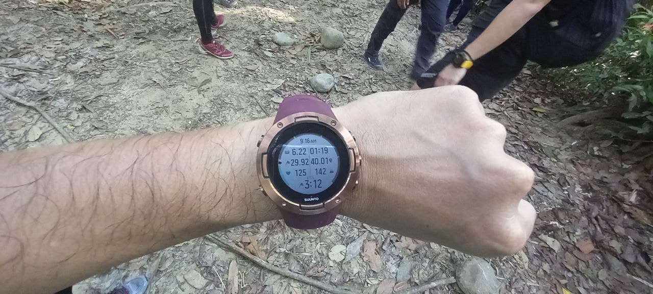
Lubuk Tedung at 6.2km
From Bukit Roket to Lubuk Tedung - 900 meters
From Starting to Lubuk Tedung - 6.2km

Junction pondok Repin and Bukit Elmo Janda Baik

The junction is 7.2km from starting point
and 1km from Lubuk Tedung
From Lubuk Tedung to Junction - 1km
From Starting point to Junction 7.2km


The waterfall is 10.8km from starting


Done Bukit Elmo
12.7km from starting point
From Junction to Peak (bukit Elmo) - 6.5km
From Start to Peak Bukit Elmo - 13.7km in 3 hours 16 minutes
(we keep on moving further up to reach 700 meters which is the highest peak according to contour as per our handheld device and come up at this spot below)

This is the peak at 700 meters above sea level
Another great hike organized by Mr Sega and his team.
Thank you for giving the opportunity