Want to try some rare mountain to climb in Negeri Sembilan? You may want to try Gunung Jono.
Located at Sri Menanti, Negeri Sembilan with 852 in height and 3.3km in distance.
Then, you may proceed another 450 meters to Bukit Sangkar Puyoh standing at 856 meters in height.
You can do it in 2 or 3 hours one way.
Then, you may proceed another 450 meters to Bukit Sangkar Puyoh standing at 856 meters in height.
You can do it in 2 or 3 hours one way.
Few points to take note:
- Almost 1km from the start (my estimation only ya), it will be all the way hard incline, please be prepared for this - cramp attack, faster heart beat
- We bumped into wild boar (grey colour) from afar but I guess the wild boar also caught by surprise on our presence and ran away, never look behind
- Leeches only at the peak and only a few, no need to worry
- The trail marker are aplenty so, chances of getting lost after you find the correct trail is minimal (except me...demmit!)
- There is no water point up there, please bring sufficient drink (again, a combination of sweet, sour, carbonate are recommended)
- For experience hiker or trail runner - this hike is easy to moderate, but may be quite challenging for low fitness level - but doable
- The trail are 100% dry
Summary of Hike
If without getting lost, the actual distance will be :
If without getting lost, the actual distance will be :
Start to Gunung Jono - 3.3km in 2 hours or so
Gunung Jono to Bukit Sangkar Puyoh - 450 meters in 13 minutes
Start to Bukit Sangkar Puyoh - 3.75km in 2 hours 15 minutes
If getting a little bit lost, like me on that day :
Start to Gunung Jono - 4.8km in 3 hours and 21 minutes
Gunung Jono to Bukit Sangkar Puyoh - 450 meters in 13 minutes
Start to Bukit Sangkar Puyoh - 5.3km in 3 hours 34 minutes
Click here for parking location:
Off-course Trail
Let me get lost so other hikers don't
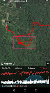
Unfortunately, we got lost as the gps navigation trail on my suunto was a little bit different from the trail in front of my eyes. It seems there is a trail in front of me but the trail was covered by low but thick bushes. So, we followed old trail marker and ended up 1.6km extra back and forth before we retrace back our step to earlier part of the trail where we begin.
The deviation off-course can be shown in rectangle shape above...wasted time and energy
The signboard at the main road
There are few junctions before you reach here, Just follow the google navigation up to this spot.
view in front of parking area, a little house in a prairie.
Turning to your left is the trailhead
This trailhead is somehow a picnic area with stream and clear water
follow the arrow
The arrow pointed at this trail marker
Its a rubber plantation area
after turning left, just go straight
it will be around 100 meters without trail marker, just keep going.
the trail here is partially covered with tall grass up to your waist/thigh...don't worry, just proceed forward
until you find next trail marker (in the circle), you are back on track
then the rest of your journey will be accompanied by visible and many trail markers
a small stream around 500 meters from start
the white big boulder - 2.5km from start
only 900 meters to go to peak of Jono...come on!!
Gunung Jono conquered!
in 3 hours 21 minutes...adoi...
4.89km from start plus the additional mileage for getting lost in the beginning
We proceed to Bukit Sangkar Puyuh...the trail continued to the left from Gunung Jono peak...can't miss it
450 meters and 13 minutes later, we reached Bukit Sangkar Puyoh
Bukit Sangkar Puyoh peak view
We started descending at 12.44pm
ended at 1.56pm in 1 hour 12 minutes


No comments:
Post a Comment