Its been a while since the last time I climbed Gunung Nuang via Janda Baik and I never put it in writing before.
Gunung Nuang have 2 entrances - via Pangsun in Hulu Langat and via Janda Baik, Bentong Pahang.
The trail from Pangsun is longer and psychology challenged but from Janda baik, it is more nearer - 6.45km one way.
Estimated Duration of Hike
Average hikers may reach the top within 3 hours to 4 hours and descending back to parking lot around 2 hours to 3 hours later.
Overall Track
Trails are clear, wide and have only one direction. Easy to navigate through even if you are a beginner.
Summary Of Hike
Total distance - 12.9km
6.45km one way
Trailhead Coordinate
3.303957, 101.887198
Breakfast and Lunch
Eating places and restaurant are aplenty along the way to the trailhead.
Parking
Last time we can park our car at the narrow road side but now the road side become narrower and being fenced, as such, the only car park in that area is at one of the land owner's. A designated parking area had been built to cater for the needs at RM5 per car. The area equipped with toilet and shower facility. If the car park is full, there is another parking lot at the side - also operated by the same land owner.
Since the parking lot is a fenced area, the problem arise if you arrive early before 6am (I think) because it is locked (I think...). So, please do take some consideration on your travel plan.
Road side parking (the blue car) and the fenced area parking lot - on the right
Toilet and shower facility
The Journey
The parking lot is the trailhead actually. You will need to cross the river.
Trailhead to The Steel Barrier (Through Vegetable Farm)
Distance - 790 meter
Time taken - 11 minutes
Trail condition - easy
The trailhead
The trailhead - This river located just in front of the parking lot. Impossible to miss it
Just cross over and head to the vegetable farm.
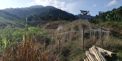
Vegetable farm like these are aplenty along the way
This is the steel barrier that once a ranger station. Just go straight following the gravel road.
Steel Barrier to Trail Junction
Last time the trail was different, I remember that I have to go into the woods soon after I cross the steel barrier, but now, we have to walk longer on the gravel road. Its long and slowly ascending.
Distance from Steel Barrier to Trail Junction - 1km
Distance from Start to Trail Junction- 1.78km
Trail difficulty - moderate ascending
Just keep going
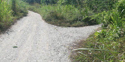
Please go straight when you reach this junction.
This junction will confuse you. straight, left or right
This is the junction trail head - with arrow sign on the photo
1.78 km from start, 26 minutes to reach here
This is where we came from - gravel road to dirt road.
If you have 4 wheel drive, you may park here
The dirt road continuation. According to the locals, this road is one big circle.
Trail Junction to Chemperoh Water Fall
Distance from Trail Junction - 1.5km
Distance from Start - 3.31km
Time Taken from Trail Junction - 30 minutes
Time taken from Start - 53 minutes
Trail Condition - moderate easy, ascending
Chemperoh Waterfall
Chemperoh water fall is at another side - little bit further
Chemperoh Water Fall to Simpang Bukit Repin
Distance From Chemperoh water fall to Simpang Bukit Repin -2.3km
Distance from Start - 5.64km
Duration taken from Chemperoh Water Fall to Simpang Bukit Repin - 1 hr 25 min
Duration taken from start - 2 hours 10 min
Trail condition - dry
Trail difficulty - hard!
Simpang Bukit Repin,
Simpang Bukit Repin to Nuang Peak
Distance from Simpang Bukit Repin to Nuang Peak -810 meter
Distance from Start - 6.45km
Duration taken from Simpang Bukit Repin to Nuang Peak - 32 minutes
Duration taken from start - 2 hours 43 min
Trail condition - dry
Trail difficulty - hard!
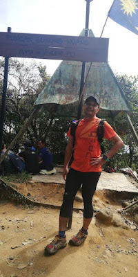
Made it to the peak
Rested around 10 minutes at the peak and headed down after that.
Estimated around 2 hours to descend down from Nuang Peak to parking lot.
Downhill all the way.
Thanks for reading.


Salam.. Ade tapak Base camp x utk diri kn khemah
ReplyDeletewkumsalam, ada tapi dekat bawah lagi, biasanya dekat area air terjun tu, lupa lak nama air terjun dia.
DeleteHi, i see that youre using ambit3 peak. May i know is the 5-sec gps on your watch is functioning well for 30 hours battery life?
ReplyDeletebcs mine is having problem when it automatically switches to 1 min gps setting in that option thus having high percentage of missing small turns in the gps map. (My 1 sec gps is working fine though).
I'm using suunto ambit 2, its an old model (ancient), to my understanding the battery power will be lesser when you reduce the gps timing
DeleteAssalamualaikum. Terima kasih untuk info. Just nak tahu,
ReplyDeletePerlu apply permit ke Pej Hutan Bentong / Hulu Langat ye untuk Naik ikut janda baik ni?
alamak, saya pun tak pasti. saya redah je hari tu...
Deletesila layari http://ecojpsm.forestry.gov.my/
Perlu. RM10.
Deletemacam mana boleh apply permit?
DeleteHi, how long it is for your to complete the climb?
ReplyDelete2 hours 43 minutes to the peak from start
DeleteHi! Is this trail open again or is it only open from the Janda Baik entrance?
ReplyDeleteNuang trail from Janda baik is always open while Nuang trail from Pangsun hulu langat just recently open - I think 2,3 months ago.
DeleteAssalamualaikum
ReplyDeleteKalau bawak anak2 boleh ke , anak2 belum pernah naik lagi Nuang so far bukit kutu dah biasa sgt. Trail ikut panduan atas ni saje ok tak? maksudnya tanpa guide?atau boleh sesat?Tq
Wkumsalam, boleh je bawak anak² kalau cik kata diorang dah naik bkt kutu. Average hike bukit kutu dgn nuang janda baik.di pun lebih kurang je.
DeleteBoleh ikut panduan kat atas tu je, kalau tak sure, masa kat area² tu ramai gak hikers yg naik dan ada gak org² kat kebun tu, boleh tanya
have you tried the Janda Baik to Bukit Repin trail and traverse the other side to Kampung Kemensah? I'm looking to do the A to B trek but unsure on trail conditions and road markers.
ReplyDeleteWah, never done that. Maybe one day
DeleteIdolaa...
ReplyDeleteNak pegi ke tu? Mmm....
DeleteEntry kat pangsun hulu langat dah buka? TK.
ReplyDeleteDah bukak dah tu...beberapa bulan dah
Deleteseriously trek pangsun dah buka? tengok fb semua cakap tak buka lagi. ada yg cakap buka sementara lah, ada yg untuk research je lah
DeleteBuka, sy baru hiking nuang baru2 ni
DeleteThis comment has been removed by the author.
ReplyDeleteemail sent
Deletesalam, nak jugak bole?
Deletenikzaid112@gmail.com
Email sent today
Deleteboleh share gpx x?
Deleterob5028@gmail.com
tq
done email to rob5028@gmail.com today
DeleteHi, maybe i know how can i get to Nuang trail via Janda baik? what is the exact location/ name of the road if to go by waze?
ReplyDeleteI'm not familiar with waze but if you're using a normal handphone, just use the google map, it will bring you to the spot
Delete